


Biological Realism
by Jack Foran
Through art, history, and scientific data, Alberto Rey examines Scajaquada Creek
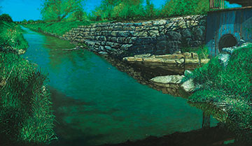
The two cultures come together in an exhibit at the Burchfield Penney Art Center focusing on Scajaquada Creek. It’s by scientist and artist Alberto Rey and includes: paintings of locations along the waterway from its origins in remote Town of Lancaster, through Cheektowaga and Buffalo to the Niagara River; jars of water (and non-aqueous matter) samples from the depicted locations; and lab analytical data on the water samples.
The paintings attest Rey’s passion about the natural environment, the scientific components an objectivity that substantiates and underscores the passion. The visible water samples and test results are a little horrifying. One of the samples from a location in Cheektowaga is a second-round sample, after the initial sample exploded due to compressed gases in the sealed jar. Never a good sign.
An information plaque about the 1972 Clean Water Act—you want to read this verbiage before perusing the analytical data accompanying the water samples—explains that the law prohibits unpermitted discharge of pollutants into waterways such as the Scajaquada. But by year 2000 there were approximately 60 permits for pollutant discharges into the creek. A large hand-drawn map of the creek on the wall above the paintings shows the number and types of permitted discharges, including a nearly unbroken line of discharge points in Cheektowaga, where test results show some of the highest pollution levels. The pollution levels—most of them, anyway—actually decrease as the creek wends through Buffalo. Part of the reason would be that the creek water from Cheektowaga is piped from Delaware Park—just before it would enter Hoyt Lake—directly to the water treatment plant on Bird Island. The water in Hoyt Lake and thus the rest of the Scajaquada is largely from underground springs.
A significant and to environmentalists controversial feature of the Scajaquada waterway is that it is tunneled through Buffalo from Cheektowaga (near the Villa Maria complex) to an outfall in Forest Lawn Cemetery. Some permitted discharges occur along the tunnel section, however.
Testing was for three parameters: E. coli, that is, fecal matter; conductivity, the capacity of the water to conduct an electrical current (test values indicate the amount of dissolved materials in the water); and turbidity, or cloudiness (test values indicate the amount of suspended materials in the water).
Five locations were sampled, one in Lancaster, two in Cheektowaga, and two in Buffalo, one at the outfall in Forest Lawn and one at West Avenue, hard by the river. At all locations, E. coli was more than twice the acceptable standard, but about 20 times the standard at one of the Cheektowaga locations. The lowest E. coli levels were in Lancaster and at West Avenue. For turbidity, test results at both Buffalo locations were actually within the acceptable standard range, the only results of all the analyses that were within standards; the Lancaster and Cheektowaga turbidity numbers were more than double the standard range. For conductivity, all test results were above—that is, exceeded—acceptable standards, but less than double acceptable standards, except at West Avenue, where the result was slightly more than double the standard.
All does not always go well with the combination art and science project. For example, the persistent (but inconsistent) mislabeling of conductivity results as turbidity, and vice-versa, on the data charts. Other problems of a similar sort.
In addition to the hand-drawn wall map, there is an aerial-view photographic map of the entire Scajaquada waterway from the year 1927, when the tunneling project was underway and about half-finished. When Humboldt Parkway was still in existence and magnificent. Before the expressway had defaced Delaware Park. (Reading—casually—about the War of 1812 over the last year or so, I had wondered to discover that Scajaquada Creek near its mouth served as a harbor and shipbuilding area for large ships. How could this be? The creek in its present configuration couldn’t accommodate a large or even small ship. The map shows—indicates—how the creek has been reconfigured. It was originally much wider for the whole length upstream from the river to about Elmwood Avenue.)
This is a generous exhibit. Lots of art and science and verbal exposition. And cases of notebooks and animal, vegetable, and mineral specimens collected on expeditions far and wide for the dual noble purposes apparently of scientific research and fly-fishing.
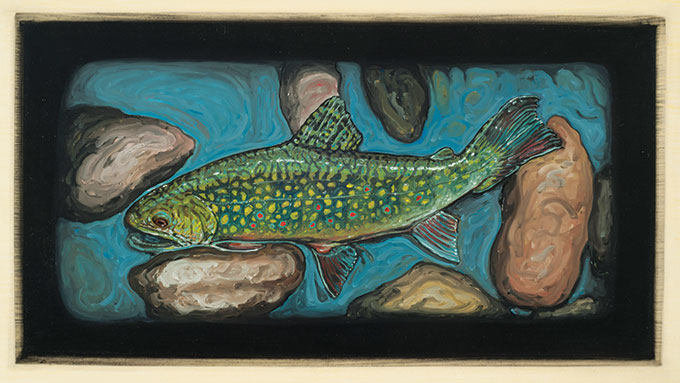
In addition to the Scajaquada paintings, there are numerous paintings of fish—trout—from more pristine waterways. All the paintings are in a daub impressionist technique, but expressionist in mood. All dark and murky, a little like the water samples.
Also, a précis history of the creek explaining how it came to be tunneled. Originally, the creek would have been used as a drinking water source. But when cholera broke out in the mid 1800s, and it was discovered that drinking water was a disease vector, a new and clean city water source was sought and found, namely, the Jubilee Springs (the same springs that now supply Hoyt Lake). But then once the creek was no longer used for drinking water, it became a major sewage and garbage disposal channel. Whereupon, due to the stench and generally unpleasant—not to mention unhealthy—character of the waterway, it was decided to tunnel it. Out of sight, out of mind.
There are also two videos, one of a midstream stroll down the creek—perhaps representing the sampling expedition—and one of a flatfish swimming in greeny water, showing off its moves. Moves like an Olympics ice dancer.
The title of the exhibit is Biological Regionalism. It runs through May 18.
blog comments powered by Disqus|
Issue Navigation> Issue Index > v13n10 (Week of Thursday, March 6) > Biological Realism This Week's Issue • Artvoice Daily • Artvoice TV • Events Calendar • Classifieds |
 Current Issue